CGIAR Indonesia-Africa SDG Workshop

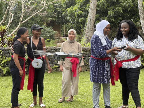
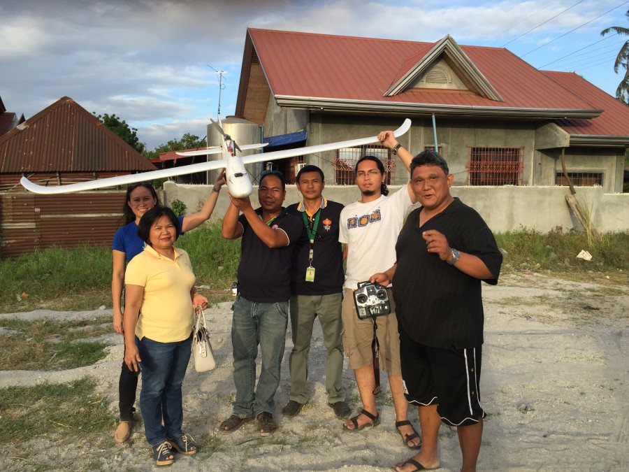
In September 2022, CGIAR funded our Open Knowledge Kit accelerated humanitarian and MSME regeneration program in Bali, Indonesia. We brought together selected technical and non-technical women and Indigenous youth to learn our accelerated program of SDG data collection, mapping, analytics and monitoring, drone operations, and Tourism and Creative Industries micro, small and medium enterprise support and market access.

Our model delivers faster, more accurate verifiable representative data using free and open source tools and low-cost equipment. Training local communities means expensive consultant, equipment, software and travel costs and carbon footprints are greatly reduced, and enable continuous and consistent monitoring while increasing local daily wages by 100 to 1700 percent.

CGIAR is a global research partnership for a food-secure future dedicated to transforming food, land, and water systems in a climate crisis. The Open Knowledge Kit program is supported under their gender and digital divide Digital Innovation Initiative.

Read CGIAR’s blog post.


Kembali: A Rebuild Bali Festival

by Celina Agaton

This year, two amazing global festivals, Ubud Food Festival and Ubud Writers & Readers Festival come together for Kembali 2020 from October 29 to November 8 to help rebuild Bali’s creative industry and artisan communities. Join me on November 4 as we screen The Fruit Hunters, a story of nature, obsession, commerce and adventure by director Yung Chang. The movie was inspired by The New York Times’ Editor’s choice book by Adam Gollner. Many of you may know Adam’s writing from Vanity Fair, Vice and Lucky Peach. Join Adam and me as we discuss his travels to remote areas to research the rarest fruit, and the state of food and heirloom farming today. Most sessions are online at https://www.ubudwritersfestival.com/kembali-2020-a-rebuild-bali-festival-set-to-reflower-indonesias-creative-industry-and-communities/


Mindanao: Agriculture, Gender Gap and Logistics Mapping

My Canadian consulting company is currently mapping the Mindanao region to support rural farming, gender, healthcare and artisan communities. The Mindanao region grows almost half the country’s food, yet remains the poorest population, with many communities at 30-70% poverty incidence. War and conflict have increased in the region in recent years, with security and safety concerns for girls and women. Our goal is to help map rural agriculture, logistics and the gender gap to plan improved infrastructure with long-term impacts on health, well-being and livelihood for girls, women, Indigenous Peoples and farm families.

This is a coordinated effort across international agencies, government, business, non-profits, academe and community leaders. Our study results will lead the prioritization and coordinated planning between international funding agencies and private investment in the second phase of this initiative.

We’ll be working with communities to teach them to map and using geospatial technologies to rapidly analyze infrastructure gaps for validation with local communities.

Local YouthMappers chapters at Far Eastern University and University of the Philippines Resilience Institute, Map the Philippines, George Washington University Humanitarian Mapping Society, and USAID GeoCenter are generously supporting the validation of these tasks.


Mapping Party for Mindanao

This slideshow requires JavaScript.

Para sa pagmamahal sa bayan! Alang sa paghigugma sa atong nasud! Thanks to your amazing efforts, in two days we were able to complete 120,500 map changes! Keep up the good work, we can do this!

Many thanks to Youthmappers in Bangladesh, Washington and France for joining us remotely!

This Valentine’s weekend, 40 participants joined our mapping party on Saturday, February 16 to help map Mindanao to support rural farming, gender gap, healthcare and artisan communities. MapPH and Youthmappers Philippines chapters at Far Eastern Universtiy Technology Junior Philippine Computer Society and UP Resilience Institute welcomed attendees to

* Learn how to map with OpenStreetMap, the Wikipedia model of maps
* Meet mappers from the public and private sector
* Join the international humanitarian mapping community
* Won prizes of free mobile data for a month and enjoyed free pizza

Learn about OpenStreetMap at https://youtu.be/suk8uRpIBQw and learn more at https://learnosm.org/

Learn how to use iD Editor to edit maps https://learnosm.org/en/beginner/id-editor/

Learn how to be a humanitarian mapping volunteer with Humanitarian OpenStreetMap https://youtu.be/8wdzGKmZu-k

Learn how to help with humanitarian mapping tasks https://learnosm.org/en/coordination/tasking-manager3/

Learn about the World Bank DRIVER Road Safety Platform https://www.roadsafety.gov.ph

#MapPHMindanao #SDGs #GenderGap #EM2030Index #OpenStreetMap #hotosm


World Food Day 2017

by Celina Agaton

This slideshow requires JavaScript.

Today is United Nations World Food Day and Indigenous Peoples Month. In the Philippines, most of our communities do not have access to safe, affordable and nearby nutrition, making food security our number one priority. This year’s theme is Change the Future of Migration: Invest in Food Security and Rural Development.

This week, from Friday, October 20 to Sunday, October 22 the 7th Likhang Habi Market Fair takes place at Glorietta until 10pm. Please come and support food, fashion and household products made by artisan weaving communities from across the country. The road to resilient communities begins with liveable wages. Please help support our local economies. #habifair2017 #MapPH


World Food Day Manila 2015

World Food Day

In honor of UN Food and Agriculture Organization’s World Food Day on Friday, October 16 Map the Philippines, Amy Besa’s Ang Sariling Atin and Purple Yam Malate and De La Salle Saint Benilde invite food community members to an informal gathering to discuss and share ideas to create more sustainable and inclusive food infrastructure in the Philippines.

Our goals for the meeting are to:

1. Create a network of food community members from farming, education, government, business NGO and community groups.

2. Outline community needs such as farm to market roads, marketplaces, training programs, funding and other funding needs to support our local food economy.

3. Visualize the network and needs on a map to identify funding opportunities and areas for collaboration across government, business and NGO sectors.

Light snacks will be served, please feel free to bring a platter and showcase your local food products at our community table.

Register at https://wfdmnl2015.eventbrite.com


After Typhoon Haiyan: Disaster and Community Resiliency

Participatory Mapping with the Municipality of Malvar, Batangas

Participatory Mapping with the Municipality of Malvar, Batangas

It’s been a while since I’ve done an update to the crisismappers network since my talk post Typhoon Yolanda/Haiyan at the International Conference on Crisis Mapping, but there are lots of good things happening here in the Philippines. The White House Office of Digital Strategy and the Office of Science and Technology Policy invited me to attend the first White House Mapathon on May 21, so I’ll be in DC until May 23 if folks want to meetup.

We’ve begun my cross sector initiative to provide a comprehensive map of the Philippines on OpenStreetMap. I’ve won a grant from Making All Voices Count to develop an open source, open data platform to provide layers of data from hazards and population, to infrastructure, disaster, community and economic reslilience needs. Some of our data partners include UNOCHA, Department of Interior and Local Government, League of Municipalities, WWF and corporate, NGO and citizen networks. One of the core functions of the platform is to identify gaps and overlaps in community needs versus publicly and privately funded programs. We aim to complete the first modules of the platform over the coming weeks to prepare for the upcoming monsoon season and 7.2 earthquake in Manila. We’re targeting high risk poverty, disaster and illegal fishing and poaching areas for disaster resilient farming projects and will be mapping this data on to the platform. This is a critical time in the Philippines with an upcoming national election in May 2016, meaning a government slow down by October 2015. We want to future proof the platform to ensure our partners are networked and running regardless of the future administration and in preparation for disasters.

The U.S. State Department’s MapGive program is generously providing satellite imagery help us map base layers on OpenStreetMap. I’ve requested Bing imagery to be refreshed countrywide to support our preparations. We would also love to be included on Missing Maps soon to help fast track our mapping.

With the World Bank and Department of Budget and Management, we are working on training local government units, colleges, cross sector partners and citizens on OpenStreetMap and a suite of other mapping tools for a more participatory planning and budgeting process on infrastructure planning.

We’re also providing free OpenStreetMap workshops across the country, including 5-day mapping training series pilots with colleges to learn OSM, JOSM and other free and opensource tools. We have a local drone partner who provide 5cm/pixel imagery for infrastructure, disaster preparedness and monitoring and evaluation and helps visualize infrastructure needs for budget proposals. We’re working with USAID AidData Fellows to work on several of our programs as well.

We’ll be piloting a Map the Philippines initiative to connect local and international mappers to local tourist and at risk area mapping activities. This is in preparation for the International Conference on Crisis Mapping which I am co-organizing in late 2016 and hosting in our new 26,000 square foot arts, tech and disaster resiliency centre. After the conference we are inviting mappers to join mapping events across the country.

Week of June 15th we’ll be organizing a free OSM training in Manila to help provide support for climate change and disaster risk mapping for the Philippines to join global Climathons with ClimateKIC on June 18 for COP21. On June 24 we’ll be hosting a Map the Philippines mapping event with OpenStreetMap Philippines and OSM Founder Steve Coast. This is in partnership with Making All Voices Count and includes a pitching competition on disaster resiliency tech with prize amounts of up to GBP20,000 or US$31K following incubation. We’ll be organizing mapathons for Disaster Resilience Reduction Day on October 13 and World Food Day on October 16.

I’ll have other updates on food security and disaster resilient agriculture soon.

Thank you for all your support so far. We’ll need help with feedback and support during these critical months and hope you can join us online and in country. We’ll have more details online soon.


Crowdsource Project for Typhoon Haiyan

by Celina Agaton

Associated Press

Associated Press

Micromappers is a great initiative where citizens can help classify disaster damage with just two clicks on your computer. With the deluge of data, social media posts, images and video that arise during natural disasters, humanitarian organizations, governments and business need your help to more quickly assess damaged infrastructure like flooded roadways, unsafe school buildings, and fallen cell phone towers.

Micromappers coconut expedition

Micromappers

For farmers, tracking the damage to destroyed fish pens, farm land and market roads can be time consuming and labour intensive.

So if you have a minute or two and are willing to a lend a helping hand, Micromappers could be a fun and simple way to get involved. Until 9pm Manila time, 8am EST Saturday, December 6, we’re helping launch the global Micromappers Coconut Expedition to help tag damage to coconut tree farms from Philippine Typhoon Glenda using images captured by our drone partners, Skyeye.

It’s a great experience and and teaching tool for kids and families, so I hope you’ll join us!

Join the coconut expedition >>


OpenStreetMap’s 10th Anniversary

Screen Shot 2014-12-01 at 1.01.13 AM

Come Join Our Celebrations for OpenStreetMap’s 10th Anniversary!

* Learn about mapping * Enjoy our drone showcase * Eat cupcakes! *

Everyone is welcome! Twitter, Instagram and Facebook Hashtag #mapPHL

Mind Museum Outdoor Canopy
J. Y. Campos Park, 3rd Ave, Taguig
Thursday December 4th 11am to 2pm
Enjoy snacks and drinks
FREE

Learn more >>

Help Spread the Word! Download the Flyer

OpenStreetMap is a collaborative project to create a free editable map of the world. It is supported and updated by 1.7 million registered users worldwide. During the Typhoon Yolanda response, as in other disasters, OpenStreetMap was widely used by the local and international aid community for its accuracy and accessibility with sharing and transferring data.

We want to help map the Philippines through free mapping workshops, citizen reporting and crowdsourced data. We’re creating mapping networks with local community leaders, colleges, government, business and NGOs to help empower Filipinos from across the sectors to collaborate together to map our communities. Our first step is to create a base layer map with roads, rivers and buildings, next we can then add additional layers such as needed infrastructure and social programming like disaster risk and preparedness, food security, health and education needs by location. We’re also bringing innovative and accessible internet access solutions and communications tools to the communities we partner with.

Learn about our exciting mapping projects and how you help become a citizen reporter with just a few clicks!

Please register so we can stay in touch with our mapping news and projects in the Philippines.

We thank our generous supporters:

World Food Program     BGC         SkyEye


World Food Day 2014

by Celina Agaton

World Food Day Siargao

Happy World Food Day from the Surigao State College of Technology’s agriculture and fisheries program! Spent the day with Mayor Coro touring sustainable food programs and drafting up mapping and livelihood projects. Fortuitous timing for this trip to happen on this day.


World Food Day Toronto

by Celina Agaton

More than half of Toronto residents live in “Food Deserts,” neighbourhoods that do not have access to good quality and affordable food.

On World Food Day, October 16, 2012, Toronto’s community leaders are coming together at the newly opened Daniels Spectrum to celebrate a cross sector approach to achieving a sustainable local food system with good food for all.

My social change film series, Films that Move and Food Forward have partnered with the Centre for Social Innovation to raise awareness and action on the challenges with hunger and the way we grow, buy and learn about the food we eat.

“Many people think of hunger as a problem exclusive to other countries, but as we know, it’s everywhere. Right here in Toronto, last year alone, there were a million visits to food banks,” says UN World Food Programme National Ambassador Against Hunger George Stroumboulopoulos. “World Food Day helps us recognize the great work currently being done in schools, businesses and communities. It also reminds us that we have a long way to go, and need an integrated approach both locally and globally to address this widespread challenge.”

World Food Day Toronto is a free event open to the public.

World Food Day
Tuesday, October 16, 2012 5:30-9pm. Doors open at 5:15
Daniels Spectrum, A Cultural Hub in Regent Park
585 Dundas Street East at Parliament. Map and Directions.
Twitter Hashtag #WFD2012 #FoodTO

5:15pm Doors Open

5:30pm Reception: Featuring food from Chef Michael Stadtlander, Paintbox and
Regent Park Community Health Centre Kitchen

6:00pm Welcome and Introductions
Opening remarks by Chef Michael Stadtlander

6:30pm Speakers
Yung Chang, The Fruit Hunters Documentary
Mark Cutrara, Cowbell
Suresh Doss, Food Truck Eats
Bryan Gilvesy, Y U Ranch/Sustain Ontario
Seana Irvine, Evergreen
Tzazna Miranda Leal, Justicia for Migrant Workers
Laura Reinsborough, Not Far From the Tree
David Reycraft, Regent Park Food Partnership/Dixon Hall
Nick Saul, The Stop
Erin Shapero, Local Food Plus

7:20pm Break

7:45pm 30-minute workshops
Topics: Community Food Projects, Food Business,
Food Centres, Street Food and Labour Rights

8:45pm Announcements and Close


Hungry for Change

by Celina Agaton

Please try entering https://graph.facebook.com/10150215706153581/photos?fields=source,link,name,images,album&limit=200 into your URL bar and seeing if the page loads.

Hungry for Change Chefs

I created Hungry for Change, a free community food fair on the way we grow, buy and learn about the food we eat, in partnership with George Brown Chef School and their Community Partnerships Office.

We screened movies on local and international food issues, served free samples of delicious local food and presented Toronto’s community kitchens, neighbourhood gardens, chefs, farmers and teachers. Participants were able to

* Sample delicious food grown right in Ontario and prepared by community
kitchens, chefs and community-friendly businesses, like Vert Catering, George
Brown Chef School, Cowbell and Fiesta Farms.

* Enjoy 10 free food booths from our community partners.

* Learn about food sustainability and community-friendly businesses from
Toronto’s food community leaders.

* Connect with free programs from urban farming and cooking classes, to
children’s activities and farmer’s markets in our street fair.

* Join a local community garden, help pick fruit trees, or share gardening and
cooking skills with your neighbours.

We announced the winner of our $2,500 prize, Young Urban Farmers.

Facebook API came back with a faulty result. You may be accessing an album you do not have permissions to access.